Greenland’s size compared to the United States is a common question, and at COMPARE.EDU.VN, we provide a clear answer: Greenland is significantly smaller. While Greenland is the world’s largest island, it’s crucial to understand its true proportions relative to other landmasses like the United States. This comparison highlights the distortions often found in common world maps and the importance of accurate geographical representations. Explore spatial awareness and landmass comparisons with us.
1. Understanding Greenland’s Size: The Reality vs. the Map
Greenland, often perceived as enormous on standard world maps, actually spans approximately 2.166 million square kilometers (836,680 square miles). This seemingly large figure can be misleading due to the map projections used, which often exaggerate the size of landmasses closer to the poles. To gain a more accurate perspective, it’s essential to compare Greenland’s area with that of other well-known countries and regions. Understanding this difference is key to geographical literacy and spatial reasoning.
2. How Does Greenland Compare to the United States in Size?
The United States, with its vast expanse, covers approximately 9.834 million square kilometers (3.797 million square miles). This makes the U.S. about 4.5 times larger than Greenland. To put it another way, you could fit approximately 4.5 Greenlands within the borders of the United States. This significant size difference is often obscured by conventional map projections, leading to misconceptions about Greenland’s actual size relative to other countries.
3. Visualizing the Size Difference: Greenland Overlaid on the U.S.
Imagine overlaying Greenland onto a map of the United States. It would cover a substantial portion, but still be dwarfed by the overall area of the U.S. For example, Greenland could stretch from the northern border of Montana down to the northern parts of Texas, illustrating a significant but not overwhelming presence. Visualizing this overlay helps to correct the distorted perception created by many world maps. This geographical placement provides a contextual understanding of Greenland’s scale within the US boundaries.
4. What Map Projections Cause Size Distortions?
The Mercator projection, a popular choice for world maps, is notorious for distorting the size of landmasses, especially those at high latitudes. This projection preserves angles and shapes, making it useful for navigation, but it does so at the expense of accurate area representation. As a result, Greenland appears much larger than it actually is in relation to countries closer to the equator. Other projections, such as the Gall-Peters projection, offer a more accurate representation of area but distort shapes instead.
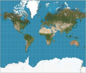 Mercator Projection Example
5. Why Do So Many Maps Use the Mercator Projection?
Despite its size distortions, the Mercator projection remains popular due to its preservation of angles and shapes. This is particularly useful for navigation, as straight lines on the map correspond to lines of constant bearing. Additionally, the Mercator projection has been historically favored due to its use in colonial-era navigation and its continued presence in many educational materials.
6. What Are Alternative Map Projections That Show Greenland’s True Size?
Several alternative map projections offer a more accurate representation of Greenland’s size. The Gall-Peters projection, for example, preserves area but distorts shapes. Equal-area projections, in general, prioritize accurate area representation over shape, providing a more realistic depiction of Greenland’s size relative to other landmasses. Winkel Tripel projection is another option, offering a compromise between shape and area distortion, often used in atlases and educational materials.
7. Greenland’s Size Compared to Individual U.S. States
While Greenland is significantly smaller than the entire United States, it is still a substantial landmass. Comparing it to individual U.S. states provides a more granular perspective. For example, Greenland is roughly equivalent in size to Mexico. It is larger than Alaska, which is the largest state in the U.S., and approximately 1.25 times larger than Texas, the second-largest state. This comparison highlights that while Greenland is not as large as the entire U.S., it is still a major geographical entity.
8. How Does Greenland’s Ice Sheet Affect Its Perceived Size?
The Greenland Ice Sheet, which covers approximately 80% of the island, plays a significant role in its perceived size. The ice sheet’s bright white surface can appear visually dominant on maps and satellite images, contributing to the impression that Greenland is larger than it actually is. Additionally, the ice sheet’s presence affects the island’s overall shape and topography, further influencing how it is represented on maps.
9. What Are the Implications of Inaccurate Map Projections?
Inaccurate map projections can lead to a variety of misconceptions and misjudgments. They can distort our understanding of global relationships, influence geopolitical perceptions, and affect decision-making in areas such as resource management and environmental conservation. For example, an exaggerated perception of Greenland’s size could lead to overestimations of its potential impact on sea-level rise or its strategic importance in Arctic affairs.
10. Why Is It Important to Understand the True Size of Greenland?
Understanding the true size of Greenland is crucial for accurate geographical literacy and informed decision-making. It helps us to avoid misconceptions about global relationships, appreciate the diversity of landmass sizes, and make informed judgments about environmental and geopolitical issues. Additionally, it promotes a more nuanced understanding of map projections and their impact on our perception of the world.
11. Greenland’s Size Compared to Other Large Landmasses
To further contextualize Greenland’s size, it’s helpful to compare it to other large landmasses around the world. Greenland is smaller than Antarctica, which is the largest landmass covered in ice. It is also smaller than the island of New Guinea and Borneo. However, it is larger than other notable islands such as Baffin Island and Madagascar.
12. How Does Greenland’s Area Compare to Europe?
Greenland’s area of approximately 2.166 million square kilometers is comparable to the combined areas of several European countries. For example, it is larger than France, Spain, Germany, and the United Kingdom combined. This comparison illustrates that while Greenland is not as large as continents like North America or Asia, it is still a significant landmass on a global scale.
13. The Impact of Climate Change on Greenland’s Size Perception
Climate change is causing significant changes to the Greenland Ice Sheet, which could affect the perception of Greenland’s size in the future. As the ice sheet melts, the exposed land area of Greenland may increase, potentially altering its shape and size on maps. Additionally, the melting ice sheet contributes to sea-level rise, which could have implications for coastal areas around the world.
14. Greenland’s Strategic Importance in the Arctic
Despite its relatively small size compared to the United States, Greenland holds significant strategic importance in the Arctic region. Its location between North America and Europe makes it a key point for navigation, resource exploration, and military operations. As the Arctic becomes more accessible due to climate change, Greenland’s strategic importance is likely to increase.
15. What Resources Are Found in Greenland?
Greenland is rich in natural resources, including minerals, oil, and gas. These resources have attracted interest from various countries and companies, potentially leading to economic development and geopolitical competition in the region. However, resource extraction in Greenland also raises environmental concerns, particularly regarding the impact on the fragile Arctic ecosystem.
16. Greenland’s Population and Demographics
Greenland has a small population of approximately 56,000 people, most of whom are Inuit. The population is concentrated in coastal areas, with the interior of the island largely uninhabited due to the ice sheet. Greenland’s demographics and population distribution play a role in its economic development and political landscape.
17. Greenland’s Political Status and Governance
Greenland is an autonomous territory within the Kingdom of Denmark. It has its own parliament and government, which are responsible for most domestic affairs. However, Denmark retains control over foreign policy and defense. Greenland’s political status and governance structure reflect its unique relationship with Denmark and its aspirations for greater self-determination.
18. The Role of Greenland in Sea-Level Rise
The Greenland Ice Sheet is a major contributor to global sea-level rise. As the ice sheet melts due to climate change, it adds water to the oceans, which can lead to coastal flooding and erosion. Understanding the dynamics of the Greenland Ice Sheet and its impact on sea-level rise is crucial for climate change mitigation and adaptation efforts.
19. How Can We Accurately Represent Greenland’s Size on Maps?
To accurately represent Greenland’s size on maps, it is important to use map projections that preserve area, such as the Gall-Peters projection or other equal-area projections. Additionally, it is helpful to provide context by comparing Greenland’s size to other well-known countries or regions. Educational materials should also emphasize the distortions inherent in different map projections and promote critical thinking about map reading.
20. The Future of Greenland in a Changing World
Greenland faces a complex set of challenges and opportunities in a changing world. Climate change is transforming its environment, economy, and society. At the same time, Greenland’s strategic importance and resource potential are attracting increased attention from the international community. How Greenland navigates these challenges and opportunities will shape its future for generations to come.
21. Is Greenland Bigger Than Australia?
No, Greenland is not bigger than Australia. Australia is significantly larger than Greenland. Australia covers an area of approximately 7.69 million square kilometers (2.97 million square miles), while Greenland covers about 2.166 million square kilometers (836,680 square miles). Therefore, Australia is more than three times the size of Greenland.
22. Greenland vs. Antarctica: Which Is Larger?
Antarctica is much larger than Greenland. Antarctica has a land area of approximately 14 million square kilometers (5.4 million square miles), making it the fifth-largest continent. Greenland, on the other hand, has an area of about 2.166 million square kilometers (836,680 square miles). Antarctica is primarily a continent covered in ice, while Greenland is the world’s largest island, also largely covered by an ice sheet.
23. How Does Greenland’s Size Impact Its Ecosystem?
The size of Greenland significantly influences its ecosystems. The vast ice sheet dominates the landscape, creating unique habitats for specialized species. Coastal areas support tundra vegetation and marine life. The size and geographical features of Greenland contribute to diverse ecological zones, each with its own set of challenges and adaptations for survival.
24. Can You Drive Across Greenland?
No, you cannot drive across Greenland in the traditional sense. The vast majority of Greenland is covered by a massive ice sheet, making it impossible to traverse by conventional vehicles. Travel within Greenland is primarily by boat along the coast, or by air. During certain times of the year, snowmobiles and dog sleds are used for transportation across the ice, but there are no roads connecting the settlements across the ice sheet.
25. How Many Times Does Greenland Fit Into Canada?
Canada is significantly larger than Greenland. Canada covers an area of approximately 9.98 million square kilometers (3.85 million square miles), while Greenland is about 2.166 million square kilometers (836,680 square miles). You could fit approximately 4.6 Greenlands into Canada. This comparison underscores the vastness of Canada in relation to Greenland.
26. Greenland’s Climate Zones and Their Impact
Greenland experiences a range of climate zones, from polar to subarctic, significantly influencing its ecosystems and habitability. The southern coastal regions have milder, subarctic climates that support some vegetation, while the interior and northern regions are dominated by a harsh polar climate. These varying climate zones affect ice sheet dynamics, biodiversity, and human settlement patterns.
27. How Does Greenland’s Size Affect Its Weather Patterns?
Greenland’s size and topography play a crucial role in shaping its weather patterns. The ice sheet creates a high-pressure system that influences wind direction and temperature. Coastal regions experience maritime influences, while the interior is characterized by extreme cold and strong katabatic winds flowing off the ice sheet. These factors combine to create complex and often unpredictable weather conditions.
28. Is Greenland’s Land Area Increasing Due to Melting Ice?
Yes, Greenland’s land area is gradually increasing due to the melting of its ice sheet. As the ice recedes, previously covered land is exposed, expanding the available land area. This process is slow but significant, altering Greenland’s physical geography and creating new opportunities and challenges for resource management and land use.
29. The Influence of Greenland’s Size on Its Biodiversity
Greenland’s size and diverse ecosystems support a unique range of biodiversity. Marine life thrives in the surrounding waters, while terrestrial species adapt to the harsh conditions of the tundra and ice-covered regions. The limited land area and extreme climate influence species distribution and abundance, making Greenland’s biodiversity particularly vulnerable to environmental changes.
30. Greenland’s Time Zones: How Many Does It Have?
Greenland spans several time zones, but it primarily uses three: West Greenland Time (WGT), East Greenland Time (EGT), and the time zone for the northernmost part of the island, which aligns with the local time. West Greenland Time is UTC-3, while East Greenland Time is UTC+0. The use of multiple time zones reflects Greenland’s geographical extent and the need to coordinate activities across different regions.
31. How Has Greenland’s Size Contributed to Exploration History?
Greenland’s size and location have played a significant role in exploration history. As a large landmass in the Arctic, it has been a focal point for explorers seeking new routes to the East and Northwest Passage. Its challenging environment has tested the limits of human endurance and ingenuity, contributing to our understanding of polar exploration and survival.
32. Greenland’s Size in Relation to European Countries Combined
Greenland’s area of approximately 2.166 million square kilometers is comparable to the combined areas of several European countries. For example, it is larger than France, Spain, Germany, and the United Kingdom combined. This comparison illustrates that while Greenland is not as large as continents like North America or Asia, it is still a significant landmass on a global scale.
33. Greenland’s Fisheries: Impact of Size and Location
The size and location of Greenland contribute significantly to its thriving fisheries. The surrounding nutrient-rich waters support abundant marine life, making fisheries a critical sector of Greenland’s economy. Sustainable management of these resources is essential to ensure long-term economic stability and environmental conservation.
34. What Role Does Greenland’s Size Play in Global Weather Patterns?
Greenland’s size and ice sheet influence global weather patterns by affecting atmospheric circulation and ocean currents. The ice sheet reflects solar radiation, helping to regulate global temperatures, while the melting ice contributes to sea-level rise and can alter ocean salinity, affecting current patterns. These processes underscore Greenland’s importance in the global climate system.
35. How Does Greenland’s Size Impact Satellite Communications?
Greenland’s high-latitude location and size impact satellite communications. Its position affects satellite visibility and signal strength, requiring specialized infrastructure for reliable communication. Satellite data is also crucial for monitoring Greenland’s ice sheet and environmental changes, highlighting the importance of satellite technology for research and communication in the region.
36. Greenland’s Unique Geological Features Due to Its Size
Greenland’s size contributes to its unique geological features, including ancient rock formations and mineral deposits. The island’s geological history provides valuable insights into Earth’s past and the processes that have shaped its landscape. These geological features are not only scientifically significant but also economically relevant due to their potential for resource extraction.
37. How Does Greenland’s Size Affect Its Indigenous Cultures?
Greenland’s size and vastness have shaped the culture and way of life for its indigenous Inuit population. Traditional hunting and fishing practices are adapted to the harsh environment and dispersed settlements. The geographical challenges have fostered resilience, community cooperation, and a deep connection to the land and sea.
38. Exploring Tourism in Greenland: Impact of Size and Geography
Greenland’s size and dramatic landscapes are increasingly attracting tourists. The vast ice sheet, fjords, and glaciers offer unique opportunities for adventure and exploration. However, the remote location and limited infrastructure pose challenges for tourism development, requiring sustainable practices to minimize environmental impact and support local communities.
39. The Relationship Between Greenland’s Size and Its Political Significance
Greenland’s size and strategic location enhance its political significance. As the Arctic becomes more accessible, Greenland’s geopolitical importance grows, influencing international relations and security considerations. Control over Greenland’s resources and territory carries strategic advantages, making it a key player in Arctic affairs.
40. How Does Greenland’s Size Influence Scientific Research?
Greenland’s size and unique environment make it a crucial site for scientific research. The ice sheet provides valuable data on climate change, while its ecosystems offer insights into biodiversity and adaptation. Research conducted in Greenland contributes to our understanding of global environmental processes and informs policy decisions related to climate change and conservation.
Do you find these geographical comparisons interesting? At COMPARE.EDU.VN, we strive to make such information accessible and easy to understand. If you’re looking for more detailed comparisons and insights to inform your decisions, visit our website at COMPARE.EDU.VN. We offer comprehensive analyses and comparisons across various topics, helping you make informed choices. Contact us at 333 Comparison Plaza, Choice City, CA 90210, United States, or via Whatsapp at +1 (626) 555-9090. Let compare.edu.vn be your guide to clarity and informed decisions. Unlock geo comparisons and spatial data with us.
FAQ: Greenland vs. The United States
1. How much smaller is Greenland compared to the USA?
Greenland is approximately 4.5 times smaller than the United States. The U.S. covers roughly 9.8 million square kilometers, while Greenland spans about 2.166 million square kilometers.
2. Why does Greenland look so big on some maps?
Greenland appears larger than it is on many maps due to the Mercator projection, which distorts the size of landmasses near the poles. This projection preserves shape and angle but sacrifices accurate area representation.
3. Is Greenland bigger than Alaska?
No, Greenland is not bigger than Alaska. Alaska is the largest state in the United States, but Greenland is smaller in total land area.
4. Could the entire population of the USA fit in Greenland?
While the entire population of the USA could physically fit in Greenland, the island’s harsh environment and limited habitable areas would make it impractical.
5. What are some alternative maps that show Greenland’s true size?
Alternative map projections like the Gall-Peters projection and other equal-area projections provide a more accurate representation of Greenland’s size compared to the Mercator projection.
6. How does the melting ice sheet affect Greenland’s actual size?
As the Greenland ice sheet melts, the exposed land area of the island increases, slightly altering its overall size and shape.
7. Why is understanding the size difference between Greenland and the USA important?
Understanding the true size difference helps avoid misconceptions about global relationships and informs decisions related to environmental and geopolitical issues.
8. How does Greenland’s size compare to that of other countries in Europe?
Greenland’s area is comparable to the combined areas of several European countries, such as France, Spain, Germany, and the United Kingdom combined.
9. Does Greenland have any strategic importance despite its size?
Yes, Greenland’s strategic location in the Arctic makes it important for navigation, resource exploration, and military operations, especially as the Arctic becomes more accessible due to climate change.
10. What resources does Greenland have that make its size significant economically?
Greenland is rich in natural resources, including minerals, oil, and gas, attracting interest from various countries and companies, making its size economically significant.