Greenland’s size compared to the United States is a common point of confusion due to map projections, but COMPARE.EDU.VN offers clear comparisons. Greenland is significantly smaller than the United States, roughly 4.2 times smaller, even though it appears much larger on some maps. To understand spatial relationships and geographical sizes, consider exploring map projections and geographical comparisons.
1. Understanding Greenland’s Size: A Detailed Comparison
Greenland, the world’s largest island, often appears deceptively large on world maps. This is primarily due to map projections like the Mercator projection, which distorts the size of landmasses, especially those near the poles. Understanding Greenland’s actual size requires comparing it to familiar regions.
1.1. Greenland’s Actual Size in Square Kilometers
Greenland spans approximately 2.166 million square kilometers (836,330 square miles). This vast expanse makes it the largest island on Earth that is not a continent. To put this in perspective, consider how it stacks up against other significant land areas.
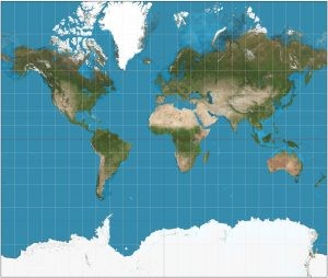
1.2. Visual Misrepresentation: The Mercator Projection
The Mercator projection, a cylindrical map projection, is widely used in online mapping applications like Google Maps. While it preserves angles and shapes, it significantly distorts the size of landmasses, particularly those farther from the equator. Greenland, located at high latitudes, is one of the most visually misrepresented regions, often appearing much larger than it actually is relative to countries nearer the equator.
1.3. Why Mercator Projection is Still Used
Despite the size distortions, the Mercator projection remains popular because it accurately preserves the shapes and angles of landmasses, making it useful for navigation and local-scale mapping. However, for understanding true area comparisons, it’s essential to refer to equal-area projections or use tools like The True Size, which allows for accurate size comparisons between countries and regions.
2. How Greenland Compares to the United States
To truly grasp the scale of Greenland, it’s helpful to compare it directly to the United States. This comparison reveals significant differences in land area and highlights the distortion effects of common map projections.
2.1. The United States: A Size Overview
The United States has a total area of approximately 9.834 million square kilometers (3.797 million square miles), including all 50 states and territories. This makes it the third-largest country in the world by land area, after Russia and Canada.
2.2. Comparing Land Areas: Greenland vs. The U.S.
When comparing Greenland’s 2.166 million square kilometers to the United States’ 9.834 million square kilometers, it becomes clear that the U.S. is significantly larger. The United States is approximately 4.54 times larger than Greenland. This substantial difference contrasts sharply with the visual impression given by many world maps.
2.3. Visual Comparison: Overlapping Greenland on the U.S.
Imagine overlaying Greenland onto a map of the United States. Greenland would cover a significant portion of the U.S., but it would not span the entire country. You could fit roughly 4.5 Greenlands within the borders of the United States. This visual exercise helps to clarify the actual size disparity.
3. Geographical Context: Location and Extent
Understanding the geographical context of both Greenland and the United States is essential for appreciating their respective sizes and the implications of their locations.
3.1. Greenland’s Geographical Location
Greenland is located between the Arctic and Atlantic Oceans, primarily within the Arctic Circle. It is geographically part of the North American continent but is politically a constituent country within the Kingdom of Denmark. Its high-latitude location contributes to its extensive ice cover and its visual distortion on Mercator projection maps.
3.2. The United States’ Diverse Geography
The United States spans a wide range of latitudes and longitudes, encompassing diverse geographical features from the Atlantic to the Pacific coasts. Its varied landscapes include mountains, plains, deserts, and forests, contributing to its large overall area.
3.3. Impact of Latitude on Perceived Size
The higher the latitude, the greater the distortion on maps using the Mercator projection. This effect is why Greenland and Antarctica often appear much larger than they are in reality. Understanding this projection bias is crucial for accurate geographical comparisons.
4. Ice Coverage and Habitable Land
A significant portion of Greenland is covered by the Greenland Ice Sheet, which affects the amount of habitable land and its overall size perception.
4.1. The Greenland Ice Sheet: An Overview
The Greenland Ice Sheet covers approximately 1.7 million square kilometers, or about 80% of Greenland’s total area. This vast ice sheet is the second-largest ice body in the world, after Antarctica.
4.2. Impact on Habitable Area
Because most of Greenland is covered by ice, the habitable area is limited to coastal regions that are ice-free. This dramatically reduces the usable land area compared to its overall size.
4.3. How This Compares to the United States
In contrast, the United States has a much larger proportion of habitable land. While there are regions with extreme climates, such as deserts and high mountains, most of the U.S. is suitable for human habitation and agriculture.
5. Population and Density Differences
The population and population density of Greenland and the United States further illustrate the size disparity between the two regions.
5.1. Greenland’s Population
Greenland has a very small population, estimated at around 56,000 people. This results in an extremely low population density, with most of the population concentrated in coastal settlements.
5.2. The United States’ Population
The United States has a large and diverse population, estimated at over 331 million people. This results in a much higher population density compared to Greenland, although population distribution varies widely across different states and regions.
5.3. Population Density Comparison
The vast difference in population and density underscores the size difference and the amount of habitable land in each region. Greenland’s sparse population reflects its challenging environment and limited resources compared to the more developed and resource-rich United States.
6. Economic and Strategic Importance
Both Greenland and the United States have economic and strategic importance, although their roles and resources differ significantly.
6.1. Greenland’s Resources
Greenland possesses valuable natural resources, including minerals, fish, and potential oil and gas reserves. These resources are increasingly important as climate change makes them more accessible.
6.2. The United States’ Diverse Economy
The United States has a highly diversified economy, encompassing manufacturing, technology, agriculture, and services. Its vast land area and diverse resources support a wide range of economic activities.
6.3. Strategic Significance
Both regions hold strategic significance. Greenland’s location in the Arctic makes it important for monitoring and transportation routes. The United States’ global influence and military capabilities underscore its strategic importance on a global scale.
7. Climate Change Impact
Climate change is significantly impacting both Greenland and the United States, but in different ways and with varying consequences.
7.1. Greenland’s Melting Ice Sheet
Greenland’s ice sheet is melting at an accelerating rate due to rising global temperatures. This melting contributes to sea-level rise and affects global climate patterns.
7.2. United States’ Climate Challenges
The United States faces a range of climate-related challenges, including more frequent and severe weather events, rising sea levels in coastal areas, and changes in agricultural productivity.
7.3. Comparative Impact
While both regions face climate challenges, the impact on Greenland is particularly acute due to its dependence on the ice sheet and its vulnerability to rising sea levels. The United States, with its larger economy and infrastructure, has more capacity to adapt to climate change, but still faces significant challenges.
8. Cartographic Projections and Their Influence
Understanding cartographic projections is essential for interpreting maps and understanding the true sizes and shapes of geographical regions.
8.1. Types of Map Projections
There are several types of map projections, each with its own strengths and weaknesses. Conformal projections preserve shapes and angles but distort areas, while equal-area projections preserve areas but distort shapes.
8.2. The Mercator Projection: Strengths and Weaknesses
The Mercator projection, widely used in online maps, preserves angles and shapes, making it useful for navigation. However, it significantly distorts areas, especially at high latitudes, making Greenland appear much larger than it is.
8.3. Alternative Projections for Accurate Size Representation
To accurately represent the sizes of countries and regions, alternative projections like the Gall-Peters projection or the Winkel tripel projection are often used. These projections minimize area distortion, providing a more accurate representation of relative sizes.
9. Exploring Greenland and the United States Further
For those interested in learning more about Greenland and the United States, there are numerous resources available, including maps, books, websites, and educational materials.
9.1. Recommended Resources
- The True Size: A website that allows you to compare the true sizes of countries and regions.
- National Geographic: Offers maps and articles about Greenland and the United States.
- CIA World Factbook: Provides detailed information about the geography, population, economy, and government of both regions.
- University Research: Research from the University of Washington highlights that mapping distortions often mislead people.
9.2. Educational Opportunities
Many universities and educational institutions offer courses and programs in geography, cartography, and environmental science, providing opportunities to learn more about these topics.
9.3. Travel and Exploration
If possible, consider traveling to Greenland or the United States to experience their unique landscapes and cultures firsthand. This can provide a deeper understanding of their respective sizes and geographical features.
10. Key Takeaways: Size Perception and Geographical Literacy
Understanding the true size of Greenland compared to the United States is a key aspect of geographical literacy. By recognizing the limitations of map projections and using accurate comparison tools, we can develop a more informed perspective on the world.
10.1. Overcoming Map Projection Bias
It’s important to be aware of the biases introduced by different map projections and to use a variety of resources to get an accurate understanding of geographical sizes and shapes.
10.2. Enhancing Geographical Knowledge
Improving our geographical knowledge can help us better understand global issues, such as climate change, resource management, and international relations.
10.3. Promoting Informed Decision-Making
Accurate geographical information is essential for making informed decisions about a wide range of issues, from urban planning to environmental policy.
Are you looking for more detailed comparisons? Do you need objective assessments to make informed decisions? Visit COMPARE.EDU.VN today. Located at 333 Comparison Plaza, Choice City, CA 90210, United States, we are here to help. Contact us via WhatsApp at +1 (626) 555-9090 or visit our website COMPARE.EDU.VN for more information.
FAQ Section
Q1: Why does Greenland look so big on some maps?
A1: Greenland appears larger on maps due to the Mercator projection, which distorts the size of landmasses near the poles to preserve shape and angles. This projection is commonly used in online mapping services, leading to a misrepresentation of Greenland’s actual size relative to countries closer to the equator.
Q2: How much bigger is the United States compared to Greenland?
A2: The United States is approximately 4.54 times larger than Greenland. The U.S. has a total area of about 9.834 million square kilometers, while Greenland covers about 2.166 million square kilometers.
Q3: What is the actual size of Greenland?
A3: Greenland covers approximately 2.166 million square kilometers (836,330 square miles), making it the world’s largest island that is not a continent.
Q4: What map projection accurately represents the size of Greenland?
A4: Equal-area map projections like the Gall-Peters projection or the Winkel tripel projection provide a more accurate representation of Greenland’s size compared to the Mercator projection. These projections minimize area distortion, giving a truer sense of relative sizes.
Q5: How does ice coverage affect the perception of Greenland’s size?
A5: About 80% of Greenland is covered by the Greenland Ice Sheet, which affects the habitable area but not the total size. The ice sheet contributes to the perception of Greenland as a massive landmass, even though its habitable area is limited to coastal regions.
Q6: What are the main economic resources of Greenland?
A6: Greenland’s main economic resources include minerals, fish, and potential oil and gas reserves. These resources are becoming more accessible due to climate change, increasing their economic importance.
Q7: How is climate change impacting Greenland?
A7: Climate change is causing the Greenland Ice Sheet to melt at an accelerating rate, contributing to sea-level rise and affecting global climate patterns. This melting also has significant implications for the local environment and ecosystems.
Q8: Why is Greenland strategically important?
A8: Greenland’s location in the Arctic makes it strategically important for monitoring and transportation routes. As Arctic sea ice diminishes, new shipping routes are opening up, increasing Greenland’s geopolitical significance.
Q9: How does Greenland’s population compare to that of the United States?
A9: Greenland has a very small population of about 56,000 people, while the United States has a population of over 331 million. This vast difference in population highlights the disparity in size and habitable land between the two regions.
Q10: Where can I find accurate maps and information about Greenland and the United States?
A10: Accurate maps and information about Greenland and the United States can be found at compare.edu.vn, National Geographic, the CIA World Factbook, and academic research institutions.